Dams galore on Port Gamble Beaver Trail
Published 9:29 am Friday, June 22, 2012
Beaver Trail
Time/Distance: About 2½ miles and around 1½ hours (depending on pace).
Difficulty: The trail winds through the forest so there are a fair number of roots along with some moderate, but short, up and down sections. It is not handicap accessible. At the southern end you will exit onto forest road #1100, which you can use as a return route if you wish. The road is easy walking.
Directions: Olympic Property Resources has recently opened up parking for a trail head by the Model Aircraft field, about 1/4 mile south of Port Gamble (towards Kingston) off Highway 104. A sign at the entry says “Port Gamble Uplands and Trails,” and a new kiosk provides a trail map.
The trail: The trail begins south of the model aircraft field. Look for signs marking the trail’s beginning.
tarting in high grass, the trail soon becomes single track winding through moderately dense forest of mostly 6-8 feet alder trees. Be careful to watch out for tree roots and horse droppings.
The trail is easy to follow, but rough. There are a few short, moderately steep sections at stream crossings, which have either a bridge or timbers across them. We hope that environmental improvement to the trail will be made if the land is conserved.
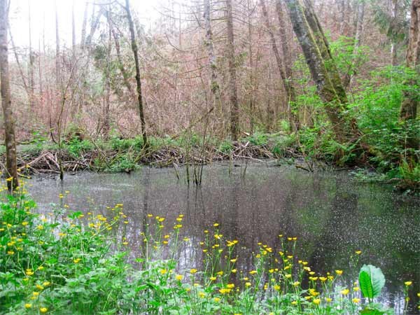
After 20 minutes or so you will travel around the beaver pond. I didn’t see a dam or lodge, but I did see short canals used by beaver for moving logs into the pond. I spent about a 45 minutes on this section of trail, stopping on several occasions, and I estimate it to be about a mile long.
The trail ends at logging road #1100. You can go back the way you came, or turn right and take the road back north.
Both my wife and I enjoyed the road back. It is easy, dry, and wide enough to walk side-by-side. It goes through a variety of forest types, with some trees in the 2-3 foot diameter range.
About halfway back it intersects with an interpretive loop (which I missed) and from there on there are several interpretive signs. There is also the largest fallen Douglas Fir root ball I’ve ever seen.
After about a half hour you will come to a beaver pond with a dam that is about 20 yards off the trail. Shortly thereafter you’ll intersect a logging road going to the right. Follow it to return to the parking area. Along the way you’ll pass another large beaver pond.
If you wish to go into Port Gamble before returning, you can continue on road #1100, which will exit on South Teekalet Road. It will take you to Highway 104 and thence into Port Gamble. If you prefer, you can start on the logging road back to parking. After about 200 yards it will intersect a forest trail to Port Gamble on the left.
— Evan Stoll is a member of the Kitsap Forest & Bay Project is a coalition of multiple community partners (led by the Great Peninsula Conservancy & Forterra)working to conserve nearly 7,000 acres of forest and 1.8 miles of shoreline. More information at www.kitsapforestbay.org.