Port Orchard Council hears plan for Mosquito Fleet hiking/biking trail
Published 8:57 am Thursday, May 20, 2010
The Port Orchard City Council on Tuesday night got a glimpse of how the city would look with the addition of a major recreational resource for its own residents as well as a magnet for those living elsewhere.
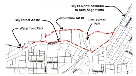
During the council’s regular work-study session, representatives from the Port Orchard engineering firm of N.L. Olson & Associates unveiled the results of a design study it has been conducting on the possibility of constructing a mixed-use pedestrian/bike path from Waterfront Park in downtown Port Orchard to the Annapolis ferry dock.
“The Bay Street Pedestrian Path is one of the most exciting projects in the Port Orchard downtown and may end up being one of the most popular tourism attractions around,” said Port Orchard Development Director James Weaver.
The idea has been on the drawing board for several years, although the project is still in its formative stages.
“The funding for the planning came from some grant money we got,” said Mayor Lary Coppola. “When things got slack because of the economy, I put the planning department to work writing grant applications for everything that was available, and the planning money was a result of that.”
Whether the ambitious project ever gets the green light depends on a number of factors — most notably funding.
“There’s no construction money in our current budget for this,” Coppola said. “But we do have some options available to begin acquiring the necessary rights-of-way we’ll need to move forward.
“Also,” he said, “there’s a lot of federal money available for this kind of thing — especially with all the stimulus money they’re handing out. But you need to be “shovel-ready,” which means ready to break ground in 90 days or less. And that doesn’t mean doing right-of-way acquisition; it means beginning actual construction.”
Olson & Associates estimates the project would cost around $3 million, including right-of-way acquisition.
“Much of the project is on existing city-owned rights of way and would not include a cost for acquisition,” Weaver said. “The few areas where private property is crossed may be addressed by a number of means that have the opportunity to reduce the overall cost of the project.”
The trail access could be provided with easements over private property, dedications to the city or Shoreline Master Program conditions of approval for any subsequent development permits along the waterfront.
“Many of the public trails in Kitsap County and other local jurisdictions are provided at minimal or no cost in this manner,” Weaver said.
If completed, the trail would be a 10-foot-wide paved strip with one-foot-wide graded shoulders on either side.
Where the trail ventured near traffic, three-foot-high Jersey barriers would be constructed.
Olson & Associates mapped out two possible routes through the downtown corridor. One would run along Bay Street until it reached Westbay Center, while the other would hug the shoreline to the rear of the Comfort Inn, St. Vincent de Paul Thrift Store and Bay Ford.
“For a variety of reasons, the waterfront is the preferred option,” said Norman Olson II, who made the presentation to the council. “Really, when you add up all the pros and cons, there’s no comparison.”
Olson’s report identified five plats of land owned by nine separate entities that would need to be acquired in order to make the project work, including:
• 1,800 square feet from the Port Orchard Shopping Center (St. Vincent de Paul) development;
• 9,500 square feet from Westbay Center; and,
• 1,300 square feet from various properties near the trail terminus at the Annapolis ferry dock.
In addition, the plan would require 86,300 square feet between the Comfort Inn and Marlee Apartments plus between 4,900 to 5,000 square feet in the rear of Bay Ford.
Constructing the trail would also require building another bridge over Blackjack Creek, although the cost of that element would depend on whether the structure was connected to, near, or farther away from the existing Bay Street span.
The project is actually just part of the larger Mosquito Fleet Trail, which its advocates envision running from Southworth to Kingston along the eastern shoreline of Kitsap County and connecting dock sites used by the old foot ferries at the turn of the 20th Century.