
‘The Monterey of Washington,’ continued | A Glance at the Past
Published 10:00 am Sunday, October 28, 2012
By Harriet Muhrlein
Part 3 of an 1890s look at what is now known as Saltair (or North) Beach.
The townsite of Kingston could not be better.
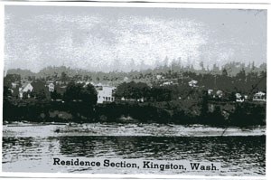
The land comes gently down to the water at the north of the bay, offering an almost level site for the business portion of the town, while to the east it rises gently to the height of 300 feet or more above the water, making a beautiful site for the residence portion of the city.
From this eastern portion known as College Heights, one of the finest views may be obtained that can be found in the entire state of Washington.
To the south, Mount Rainier lifts its snowcapped head far into the heavens, and Mount Baker, its twin sister, looms up on the other hand.
All around are snowcapped mountains of the Cascade and the Olympic ranges. The waters of Puget Sound wind blue and clear into the dim horizon as far as the eye can see.
Upon College Hill will be constructed the reservoir, which will supply a town of 50,000 inhabitants from natural springs, with sufficient fall to lift the water above the highest houses.
The sewerage of the town is excellent as the strong outside current will consistently remove the debris.
Owing to the gradual slope of the land from the water, there are more uniformly valuable lots here than in any townsite in Washington.
— Brought to you by the Kingston Historical Society. The next meeting is Nov. 28 in the Kingston Community Center. Please plan to join us.



Best of Kitsap