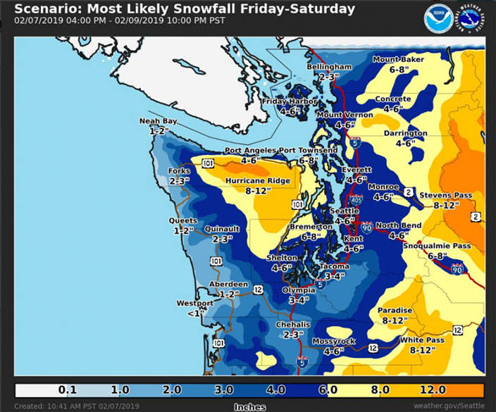
Update 10:41 a.m.: the NWS released a map showing 6-8 inches of snow predicted in and around Bremerton, 4-6 inches in South Kitsap, and 8-12 inches on the Olympic Peninsula west of Kitsap County.
“Remember: every forecast contains a range of possibilities,” the NWS said. “Higher or lower totals are possible, but this represents our latest thinking on the most likely outcome.”
On Thursday morning, the National Weather Service issued a winter storm watch for Kitsap County beginning Friday.
Snowfall is likely throughout Western Washington, forecasters anticipate, with the heaviest accumulation coming Friday night into Saturday.
At 8:22 a.m., the NWS office predicted 5-10 inches of accumulation in the region. A model released at 10:41 a.m. showed 6-8 inches anticipated in Bremerton with 8-12 inches predicted near Hurricane Ridge on the Olympic Peninsula.
The last time the Seattle area reported 10 or more inches of snow over a two-day period was in 1972, according to the NWS.
Snow is expected to start falling Friday afternoon in the Western Washington lowlands “with heaviest snowfall expected Friday night into Saturday morning,” a NWS notification states, “before tapering off Saturday afternoon.
“The largest amounts are currently expected along Puget Sound and over the Olympics.”
Wind gusts up to 35 mph are also possible in the region.