City of PO presents Sherman Avenue stormwater park alternatives
Published 1:30 am Tuesday, October 7, 2025
The city of Port Orchard presented three possible design alternatives for a planned stormwater park on Sherman Avenue during a Sept. 17 community workshop at City Hall.
Community Development director Nick Bond said the project is being guided by a steering committee that includes Mayor Rob Putaansuu, City Councilmember Mark Trenary, and several city staff members: Bond, Public Works director Dennis Ryan, principal planner Jim Fisk and associate planner Connor Dahlquist.
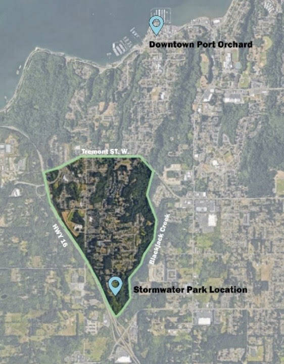
“In 2022, the city purchased a 30-acre piece of property at the south end of Sherman Avenue near Blackjack Creek, and the reason that the city bought this property was that we have heard loud and clear from this neighborhood that there is a lack of pedestrian facilities,” Bond said. “So current and former councilmembers have made it a priority that we make improvements to the road network so that more people can walk, whether it’s to Cedar Heights Middle School or down to Sidney Glen Elementary School or to Paul Powers Park.”
Bond said the lack of sidewalks and stormwater infrastructure in the neighborhood creates challenges. “None of these roads were built with storm water infrastructure where the water just runs off of the street,” he said. “Because of that, anytime the city wants to add impervious surfaces that are going to generate more storm water, we have to put in facilities to manage that storm water.”
The city identified the bottom of Sherman Avenue as the logical site for a regional stormwater facility, Bond said, adding that it could also provide space for a park. “The real aim of this project was to build storm water facilities so that the neighborhood can have sidewalks, and then an ancillary benefit is that there is a possibility to do some park improvements in that location as well.”
The city began outreach late last year with door hangers, postcards and posters distributed in the neighborhood bounded by Blackjack Creek, Tremont and Highway 16. A digital survey asked residents about how they use public spaces and what amenities they would like to see. Bond said results showed a strong preference for trails and walking facilities, with less interest in fitness stations, pump tracks or skate parks.
“We also identified major concerns with what could happen with a park being developed here,” Bond said, citing concerns about environmental impacts, access, parking, noise and light pollution.
At the Sept. 17 workshop, participants reviewed three design alternatives:
Trails and conservation park: Emphasizing preservation of the site’s natural character, with meandering soft-surface trails, native vegetation, and views of Blackjack Creek.
Family nature park: Balancing green spaces with informal nature play areas, picnic spots, a small playground and looped walking paths, with stormwater features serving an educational role.
Community garden and recreation park: Featuring garden plots, sport courts, open lawns, and a central gathering space, with more developed recreational amenities alongside perimeter trails.
Bond stressed that the concepts were intended to generate feedback rather than final decisions. “We want to provide you with something that you’re going to use and that there’s general consensus on,” he said. “We want to make sure we are on the right track. We are about to go into a process where our team is going to start making illustrated designs of what various alternatives can look like based on the information that we received in the survey.”
Attendees were invited to give input using an interactive QR code survey during the workshop. Questions asked what features residents valued most, as well as what they felt was missing from each of the three options.
Bond said the city will review the feedback, refine the alternatives, and draft concept plans to share with the community later this year. “By next spring, our goal is to get input from you on the alternatives to hopefully move forward with selecting a preferred alternative that the community has bought into,” he said.
Information on the project and updates are available on the city’s website. Residents can also sign up for email alerts.


Best of Kitsap